Alkuperäinen tiedosto(1 290 × 1 170 kuvapistettä, 599 KiB, MIME-tyyppi: image/png)

Tämä tiedosto on jaettu kohteesta Wikimedia Commons ja muut projektit saattavat käyttää sitä. Tiedot tiedoston kuvaussivulta näkyvät alla.

Yhteenveto

Wikipedia

 Tämä on suositeltu englanninkielisessä Wikipediassa (Featured pictures) ja on hyväksytty yhdeksi hienoimmista kuvista.

Jos tämän tiedoston pitäisi olla mielestäsi suositeltu myös Commonsissa, voit vapaasti asettaa sen ehdolle.
Jos sinulla on vastaavan laatuinen kuva jonka voit julkaista sopivalla tekijänoikeuslisenssillä, voit tallentaa sen, merkitä lisenssin ja asettaa sen ehdolle.

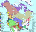
Distribution of North American language families north of Mexico

Info

About sources

Map redrawn and modified primary based on two maps by cartographer Roberta Bloom appearing in Mithun (1999:xviii–xxi). Incidentally, these maps are very derivative of the Driver map of the 1950s–60s (which means that, although published in 1999, it is not as up-to-date as one might think). The other main source used is the up-to-date and very well-done map found in Goddard (1996), which was revised as Goddard (1999). Essentially, Bloom's map was used for the projection and general outline of language borders while Goddard's maps were used to adjust Bloom's borders to reflect the more recent research.

Additional references include Sturtevant (since 1978), Mithun (1999:606–16), and Campbell (1997:353–76). Mithun and Campbell have several maps based on the maps found in Sturtevant (since 1978) and Bright (1992).

Mithun, M. (2001) The Languages of Native North America, Cambridge Language Surveys, Cambridge University Press ISBN: 978-0-521-29875-9.

About map content

  • Map delineates each language family in a unique color.
  • Language isolates are all in dark grey, e.g. Chitimacha (#7) is an isolate in Louisiana. This is not meant to imply any relationship among them whatsoever. All isolates are assigned a number and listed on the right side of map.
  • Unclassified languages (i.e. #1 Beothuk, #4 Calusa, #8 Adai, #10 Karankawa, #12 Aranama, #15 Solano, #19 Esselen, #26 Cayuse) are in light grey and are also assigned a number and listed with the isolates on the right. (Unclassified languages in the case of North America are unclassified because there is not sufficient data to determine genealogical relationship.)
  • Areas in white are either
    1. uninhabited (in Alaska, Canada, Greenland),
    2. unknown (due to early extinction and little or no data; this is mostly in the East), or
    3. outside of subject area (in Mexico). (note that Seri (#17) is included because it is usually considered part of the Southwest culture area and also included in various Hokan phylum proposals.)
  • This is a historical map: Although most languages are still spoken in North America, the extent of their distribution has been profoundly affected by European contact — many languages have become extinct (sometimes including even the peoples). (See Endangered language.)
  • Language areas are those at earliest time of European contact, as far as can be determined. Since contact occurred at different times in different areas, no historical Native American maps of the entire continent are of a single time period.
  • Language areas are not as well-defined as this map would suggest: borders are often fuzzy and arbitrary and the entire language area may not be fully occupied by language speakers.
  • Na-Dene here is Athabaskan-Eyak-Tlingit, excluding Haida (#28).
  • The following groupings are disputed by some (or are considered not fully demonstrated):
    1. Plateau Penutian (aka Shahapwailutan) = Klamath-Modoc (isolate) + Molala (isolate) + Sahaptian (family). Sometimes Cayuse (#26) is included in Plateau Penutian, but this language is not very well documented and is now extinct. Thus, it is considered unclassified here.
    2. Yuki-Wappo = Yuki (isolate) + Wappo (isolate).

To do

  • translation into Spanish & other languages
  • extend Mexico coverage (for Comecrudo)?

Links

You might want to compare this map with these two older (1967) maps of only the USA:

There is also an Inuktitut dialect map in Wikipedia:

Be sure to check out the beautiful work of Mutur Zikin (www.muturzikin.com):

Looking for more maps of South America? Go here:

A (older) map of Mexico (provided by the University of Texas):

Some pages in Wikipedia:

Some other sites on American languages (in English):

You might also be interesting in:

Other maps in this series

These other maps of single families are generated from the main map above.

Bibliography

  • Bright, William (Ed.). (1992). International encyclopedia of linguistics (Vols. 1-4). New York: Oxford University Press.
  • Campbell, Lyle. (1997). American Indian languages: The historical linguistics of Native America. New York: Oxford University Press. ISBN 0-19-509427-1.
  • Driver, Harold E. (1969). Indians of North America (2nd rev. ed.). Chicago: Chicago University Press. (Original work 1961).
  • Goddard, Ives. (1996). Native languages and language families of North America [Map]. In I. Goddard (Ed.), Handbook of North American Indians: Languages (Vol. 17). (W. C. Sturtevant, General Ed.) Washington, D. C.: Smithsonian Institution. ISBN 0-1604-8774-9.
  • Goddard, Ives. (1999). Native languages and language families of North America (rev. and enlarged ed. with additions and corrections). [Map]. Lincoln, NE: University of Nebraska Press (Smithsonian Institute). (Updated version of the map in Goddard 1996). ISBN 0-8032-9271-6.
  • Krauss, Michael. (1982). Native peoples and languages of Alaska (rev. ed.). [Map]. Fairbanks, AK: Alaska Native Language Center. ISBN 0-933769-00-8.
  • Mithun, Marianne. (1999). The languages of Native North America. Cambridge: Cambridge University Press. ISBN 0-521-23228-7 (hbk); ISBN 0-521-29875-X.
  • Powell, John W. (1891). Indian linguistic families of America north of Mexico. Seventh annual report, Bureau of American Ethnology (pp. 1-142). Washington, D.C.: Government Printing Office. (Reprinted in P. Holder (Ed.), 1966, Introduction to Handbook of American Indian languages by Franz Boas and Indian linguistic families of America, north of Mexico, by J. W. Powell, Lincoln: University of Nebraska).
  • Sebeok, Thomas Albert (Ed.). (1973). Current trends in linguistics: Linguistics in North America (Vol. 10, Pts. 1-2). The Hague: Mouton.
  • Sturtevant, William C. (Ed.). (1978-present). Handbook of North American Indians (Vols. 1-20). Washington, D. C.: Smithsonian Institution. (Vols. 1-3, 16, 18-20 not yet published).

Thank You

Thanks goes to:

Lisenssi

w:fi:Creative Commons
nimeäminen
Tämä tiedosto on lisensoitu Creative Commons Nimeä 2.0 Yleinen -lisenssillä.
Voit:
  • jakaa – kopioida, levittää ja esittää teosta
  • remiksata – valmistaa muutettuja teoksia
Seuraavilla ehdoilla:
  • nimeäminen – Sinun on mainittava lähde asianmukaisesti, tarjottava linkki lisenssiin sekä merkittävä, mikäli olet tehnyt muutoksia. Voit tehdä yllä olevan millä tahansa kohtuullisella tavalla, mutta et siten, että annat ymmärtää lisenssinantajan suosittelevan sinua tai teoksen käyttöäsi.

Kuvatekstit

Lisää yhden rivin pituinen kuvaus tästä tiedostosta
Location of tribal languages on Turtle Island at time of first european contact, abstracted from US ethnology studies

Kohteet, joita tässä tiedostossa esitetään

esittää

Tiedoston historia

Päiväystä napsauttamalla näet, millainen tiedosto oli kyseisellä hetkellä.

(uusimmat | vanhimmat) Näytä [10 | 20 | 50 | 100 | 250 | 500] kerralla. ← 10 uudempaa |
PäiväysPienoiskuvaKokoKäyttäjäKommentti
nykyinen20. heinäkuuta 2019 kello 17.28Pienoiskuva 20. heinäkuuta 2019 kello 17.28 tallennetusta versiosta1 290 × 1 170 (599 KiB)DennissReverted to version as of 21:52, 1 March 2009 (UTC)
13. heinäkuuta 2019 kello 16.54Pienoiskuva 13. heinäkuuta 2019 kello 16.54 tallennetusta versiosta1 290 × 1 170 (840 KiB)Thylacinus cynocephalusHaving colonial borders on an indigenous language map is offensive
1. maaliskuuta 2009 kello 21.52Pienoiskuva 1. maaliskuuta 2009 kello 21.52 tallennetusta versiosta1 290 × 1 170 (599 KiB)Malus Catulusoptipng, pngout
22. joulukuuta 2006 kello 14.31Pienoiskuva 22. joulukuuta 2006 kello 14.31 tallennetusta versiosta1 290 × 1 170 (668 KiB)Mahahahaneapneappngcrushed
11. marraskuuta 2006 kello 00.43Pienoiskuva 11. marraskuuta 2006 kello 00.43 tallennetusta versiosta1 290 × 1 170 (916 KiB)Ish ishwarupdate
1. huhtikuuta 2006 kello 04.55Pienoiskuva 1. huhtikuuta 2006 kello 04.55 tallennetusta versiosta1 296 × 1 176 (678 KiB)Locke Colesmaller file (pngout /f0 Langs_N.Amer.png /b4096) / Change: -315546 bytes ( 68% of original)
7. tammikuuta 2006 kello 04.01Pienoiskuva 7. tammikuuta 2006 kello 04.01 tallennetusta versiosta1 296 × 1 176 (986 KiB)Ish ishwaradai,chimariko = unclassified; adjust uto-aztec, salinan, southern athabasc., muskogean; + Isla Ángel de la Guarda, Isla del Tiburón, Lake Okeechobee
9. joulukuuta 2005 kello 21.24Pienoiskuva 9. joulukuuta 2005 kello 21.24 tallennetusta versiosta1 318 × 1 195 (714 KiB)Ish ishwarchecker grid pattern to Chumash
6. joulukuuta 2005 kello 06.12Pienoiskuva 6. joulukuuta 2005 kello 06.12 tallennetusta versiosta1 318 × 1 195 (714 KiB)Ish ishwarforgot seri, fix fam key
6. joulukuuta 2005 kello 01.21Pienoiskuva 6. joulukuuta 2005 kello 01.21 tallennetusta versiosta1 318 × 1 195 (712 KiB)Ish ishwarupdate
(uusimmat | vanhimmat) Näytä [10 | 20 | 50 | 100 | 250 | 500] kerralla. ← 10 uudempaa |

Seuraava sivu käyttää tätä tiedostoa:

Tiedoston järjestelmänlaajuinen käyttö

Seuraavat muut wikit käyttävät tätä tiedostoa:

Näytä lisää tämän tiedoston järjestelmänlaajuista käyttöä.

Metatieto